La Société Guernesiaise’s view on the proposed development at Longue Hougue South
La Société Guernesiaise has engaged with this process since being invited to the Scoping Opinions Workshop for the Longue Hougue South Environmental Impact Assessment (EIA) in February 2019. We have undertaken research, contributed data, and provided expert advice throughout this process.
Unfortunately, despite this, the published EIA does not address the environmental concerns we have raised; it contains information which misinterprets data sets and disagrees with independent expert advice.
All these concerns have been highlighted to both the consultants and to the Committee for the Environment & Infrastructure, but have not been addressed.
We are raising these concerns publicly now so that the Guernsey community is aware of the potential ecological impacts of the proposed development, and can ensure that the decision made by the States of Deliberation on the 22nd April is an informed decision.
Our concerns and opposition to the proposed development have been shared by experts and other environmental organisations, such as the Alderney Wildlife Trust. Their letter of support of La Societe can be read here.
Main Concerns
1. Loss of scaly cricket habitat and populations
The Atlantic scaly cricket (Pseudomogoplistes vicentae) is a small and unassuming insect. It is restricted to a very particular habitat where it lives in shingle banks and lays its eggs in driftwood. But this obscure creature is one of Guernsey’s most endangered species.
It is a species of international importance and is classified as ‘Vulnerable’ on the IUCN Red List. To put that in perspective – that is the same classification as the African elephant and the snow leopard. It means that it is considered to be “facing a high risk of extinction in the wild”[1] and so conservation measures are required to protect the species and its habitats.
It is known from a very restricted number of sites worldwide and only 3 in the British Isles. Trapping at Longue Hougue South found a very high population density, making it an important population for this internationally vulnerable species.
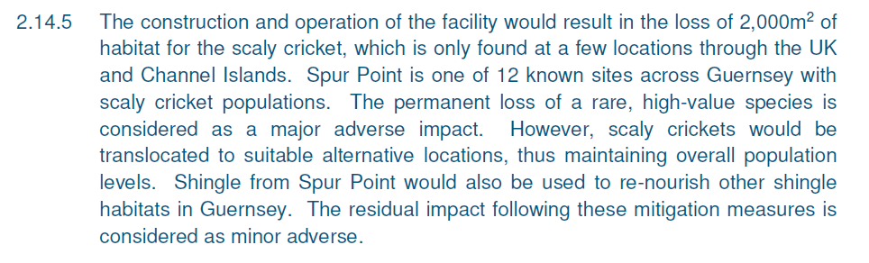
If this development continues it will lead to the loss of this shingle bank and so the loss of this habitat for scaly cricket. This was assessed as a ‘Major Adverse Impact’ in the EIA.
The proposed mitigation for this loss is to trap and move the crickets from Spur Point to Belle Greve Bay. Unfortunately, this method has never been attempted and similar projects using lab reared specimens have failed. The world’s leading expert on the scaly cricket, Professor Karim Vahed, has said “there is no evidence that translocation will work for this species” and also that moving individuals won’t likely protect the population, which are limited by the availability of suitable habitat”.
The likely failure of this mitigation has not been included in the EIA which subsequently downgraded the impact to “Minor Adverse”. Given current scientific advice, this reclassification is not justified.
You can read Professor Vahed’s full response to the EIA here.
2. Loss of an Eelgrass Bed
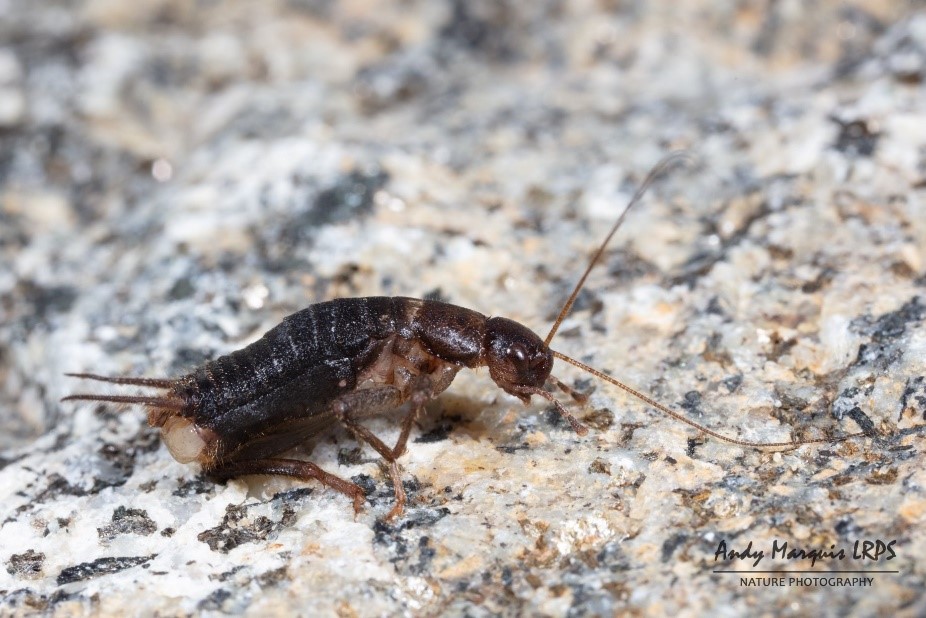
An eelgrass bed is a habitat made up of a marine plant called eelgrass (Zostera marina). The habitat is of international importance for many reasons: it plays an important role in climate mitigation through carbon sequestration; it stabilises sediment; it acts as a nursery ground for many commercial fish species; and it supports a diversity of other marine life, including short-nosed seahorses.
In the UK it is designated as a Priority Habitat, in Europe it is protected under the Habitats Directive and it is protected worldwide through the OSPAR Convention.
Here in Guernsey, areas have been lost due to developments, damage from moorings and due to the spread of the invasive seaweed Japanese wireweed (Sargassum muticum).
Spur Point is home to roughly 12,000m2 of eelgrass which amounts to roughly 10% of all known eelgrass beds in Guernsey.
A snorkel survey was conducted of this site in 2019, you can see a video clip of this incredible area here:
If this development continues it will lead to the loss of this area of eelgrass and all sedentary species which live there.
The proposed mitigation for this loss is to move the eelgrass to another location, which has not yet been determined. Eelgrass translocation has been attempted many times and there is usually a 35% survival rate for the eelgrass plants. This, however, does not take into account the risk of invasion from Japanese wireweed which readily establishes in disturbed eelgrass beds. Nor does it consider the potential loss of habitat which already exists at the new site.
Given all these uncertainties we do not agree with their assessment that there will likely be a very small loss of eelgrass, nor with their classification of the impact as “Minor Adverse”.
Marine Ecologist Dr Broadhurst-Allen has recommended that the eelgrass bed within the Longue Hougue South development site be preserved due its conservation importance and low likelihood of the mitigation being successful. You can read her full report here.

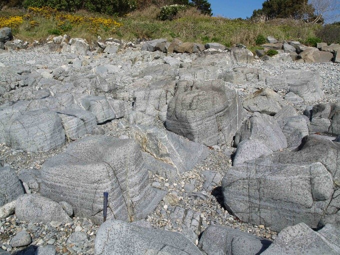
3. Unique Geology
The St Peter Port Gabbro is an igneous rock intrusion, found along the East coast of Guernsey from St Peter Port Harbour to Vale Castle. The outcrop found at Spur Point is of a totally different character to the rest of the formation. It is very unusual due to its unique layering (bands of black Hornblende crystals interspersed with bands of light grey Feldspar) and mineral assemblage. There are also places where the Hornblende crystals are arranged in small circular patterns known as “Orbicular Structures”. As yet, nobody has satisfactorily explained the origin of these arrangements.
Several prominent geologists have written that the outcrop at Spur Point has no direct equivalent anywhere in the world. John Renouf, Fellow of the Geological Society has written that “It could be said that if one set out to create the most favourable gabbro outcrops in all senses, then it would be hard to improve on those of Spur Point”.
The development of Spur Point would destroy a large proportion of the St Peter Port Gabbro. The Gabbro that remains would have very limited accessibility for visiting geologists.
The proposed mitigation measures for the loss of the St Peter Port Gabbro are to place boulders onshore. This is unsatisfactory for a number of reasons. The boulders quickly become overgrown with mosses and lichens, making observations of the structure and mineralogy challenging. More importantly, geologists would not be able to observe variations across the outcrop, vital for robust investigation of the geological history of the area.
4. Close proximity to maerl
Maerl is a habitat formed of nodules of encrusting red algae which develops into a gravelly substrate. It is a rare habitat which has become scarcer due to human activities such as pollution, dredging and marine developments. Maerl is also incredibly slow growing, taking millennia to develop into mature beds, so once damaged it is not likely to recover. It is so slow growing that it is considered a non-renewable resource.
Maerl is also an extremely diverse habitat – its nodules provide a complex structure which supports incredible assemblages of algae, marine invertebrates, and is a spawning ground for many species of fish.
Because of its rarity, fragility and ecological importance, it is one of the most protected marine habitats found in our waters. Like eelgrass, in the UK it is designated as a Priority Habitat, in Europe it is protected under the Habitats Directive and it is protected worldwide through the OSPAR Convention.
One of only four known maerl beds in Guernsey’s waters is found just east of Longue Hougue.

Whilst the maerl at Longue Hougue is not within the footprint of the proposed development, it is only approximately 240m away and so could be impacted by a change in tidal flow, velocity or an increase in suspended substrates. Maerl beds are highly sensitive to environmental changes such as these, and if damaged are not likely to recover. Thus, this development has the potential to permanently damage this area of maerl.
Because the EIA states it will not be impacted by this proposed development it has not recommended any mitigation or monitoring of the maerl bed. This assessment is purely based on modelling, which we know has an inherent margin for error. Given the close proximity, international importance, and potential for irrevocable damage, we believe this margin of error is too great to put this maerl bed at risk.
Only three maerl beds have been recorded off Guernsey. Seasearch suggest that – “the precautionary principle should be applied to prevent unsustainable damage to this non-renewable and highly-biodiverse habitat”. You can read their full report here.
A video of the maerl bed adjacent to Longue Hougue South is available to view here.
5. A beautiful environment
In addition to the major environmental impacts described above, this area of Guernsey has its own intrinsic value.
It is comprised of many locally important habitats which support a range of wildlife:
- The shingle banks, as well as supporting scaly crickets are also home to many specialist wildflowers, invertebrates and are foraging grounds for birds. They are a relatively scarce habitat in the island and are at risk from rising sea levels and coastal infrastructure.
- The foreshore, as well as containing eelgrass, also contains rock pools, gravel and kelp forests – these are also ecologically important and locally valuable habitats.
This development would lead to the loss of all these habitats. This loss cannot be mitigated for, nor can it ever be reversed.
Spur Point has long been known as a place of quiet refuge for many walkers, beach foragers and sea anglers. Whilst it is not as popular as many beaches along the sandy west coast, it is all the more special for that.
This proposed development will deprive Guernsey of this natural treasure.
6. Data gaps
The above concerns are based on available data and known important features. Whilst the EIA strived to undertake a baseline assessment, it did not conduct comprehensive surveys of large areas of the site and so many impacts may still not be understood. An EIA which is not based on accurate data cannot accurately assess the potential impacts of a development.
The modelling of the changes in tidal flow and velocity caused by this proposed development indicated changes in areas around the development. No surveys have been undertaken of these areas so it is not possible to say what potential impact these changes will cause.
No benthic surveys have been undertaken inside the footprint of the site. Isolated grab samples are not a substitute for systematic dive surveys and even those were obtained from outside the footprint of the development.
Recommendations from survey reports have not been followed up or addressed. The Phase II Intertidal Survey identified many knowledge gaps in the understating of important habitats and recommended that these be investigated further. No explanation has been given as to why these recommendations have been dismissed.
Throughout the EIA the appropriateness of datasets and the interpretation of reports has been dubious. We wish to avoid listing every inaccuracy, so have instead highlighted a couple of examples which are indicative of a common problem within the compilation of the EIA.
Fish species were assumed absent due to their absence in a large European data set. The data collected from Channel Island waters was only obtained in sites east of Sark, so is not representative of species likely to be found in close coastal waters. Also the absence of a species from this dataset it taken as proof of absence from the site. One notable interpretation of this data set is that it does not include mackerel – a common species from around our waters.
This misinterpretation of data is more dangerous due to the absence of systematic surveys from our island. Without these surveys which have actively looked for important species, it is not possible to presume they are not present at the site. However, this is done repeatedly throughout the EIA.
What are the alternatives?
Longue Hougue South was chosen as the preferred site (or Best Practicable Environmental Option) following a high-level EIA. This EIA ranked a list of 20 sites based on 36 Decision Criteria, which included only two ecological considerations:
- Is the site located within or adjacent to a Site of Special Significance?
- Is the site located within or adjacent to an Area of Biological Importance?
We have several concerns with this limited assessment criteria:
- These are designations under the Island Development Plan, which is only applicable to areas of land above the mean high-water mark and so cannot be used to assess the importance of marine sites.
- International best practice guidance is that the presence of locally, nationally or internationally important species and habitats should also be considered in this high-level EIA process, however this criteria was removed prior to assessment.
- The intertidal zone was recommended for SSS designation during the island wide assessment in 2016, due to the ecological importance of these sites. It was rejected for designation as a SSS (and subsequently designated an ABI, a designation which does not afford the same level protection) not because of lack of ecological importance, but because the Planning Authority felt this may place undue restrictions on the users of beaches. This highlights the ecological importance of intertidal sites.
Were the high level EIA process more robust and the appropriate criteria included (also recognising that the presence of both Atlantic scaly cricket and eelgrass habitats would need to have been known at the time), it is likely that LHS would have been discounted on environmental grounds. Other sites were rejected on environmental grounds, including Black Rock, which was “not selected for further assessment due to major environmental constraints”[1]. This constraint is listed as the presence of maerl habitat which, like eelgrass, is a European protected habitat.
Even based on these limited assessment criteria, LHS ranked 9th out of 20 sites. The top ten ranked sites were as follows:
- Airport Runway Extension (eastern end)
- Guillotine Quarry[2]
- Raising level of existing Land Reclamation at Longue Hougue
- Les Vardes Quarry
- Increase in re-use / recycling of inert waste
- Temporary Stockpile at Longue Hougue
- Paradis Quarry
- L’Epine Quarry2
- Longue Hougue South
- East of QEII Marine (St Peter Port)
Whilst we recognise that many of the above listed options may also have significant environmental impacts following more detailed site assessments, it is unlikely that any will lead to such significant ecological impacts as Longue Hougue South.
We believe that this site assessment process, and these alternative options, needs revisiting before an alternative site can be proposed.
Given the likely economic difficulties the island will face following the unprecedented situation caused by Covid-19 and predicted slow down of the construction industry, it is likely that finding a solution to the disposal of inert waste has become less urgent and so there is now time to revisit these options.
Given the high capital cost of this proposed development, ensuring money is spent wisely and strategically is more important than ever.
Whilst we recognise that many of the above listed options may also have significant environmental impacts following more detailed site assessments, it is unlikely that any will lead have such significant ecological impacts as Longue Hougue South.
[1] State of Guernsey Inert Waste Strategy, Royal Haskonings DHV, 2017 https://gov.gg/CHttpHandler.ashx?id=110936&p=0
[2] The States of Deliberation resolved to undertake further investigation of these sites, however due to the refusal of funding for an EIA no further investigation has taken place.